Research Highlights
Wildfire, Soil Moisture, Evapotranspiration, and Runoff
|
Dr. Kinoshita collaborated on a publication entitled "Simulating Surface and Subsurface Water Balance Changes Due to Burn Severity," which was published in Vadose Zone. As mega-fires are becoming prevalent, understanding the hydrologic response across a range of burn severities is increasingly necessary to quantify risks to water resources. The primary objective of this work was to investigate the interplay between overland flow and evapotranspiration for several burn severity scenarios to quantify possible water balance responses at the hillslope scale. We compared pre- and post-fire hillslope-scale hydrologic responses using a coupled surface and subsurface numerical model. The reduction of evapotranspiration often dominated the new water balance compared with the increase in overland flow, resulting in higher soil moisture. This modeling experiment also identified a tipping point where increased overland flow from high burn severity sites overshadows the effect of reduced evapotranspiration on the water balance, causing comparatively drier post-fire soils.
Web stories: https://www.soils.org/discover-soils/story/fire-effects-soil-moisture-runoff https://www.crops.org/science-news/fire-effects-soil-moisture-runoff https://www.agronomy.org/science-news/fire-effects-soil-moisture-runoff |
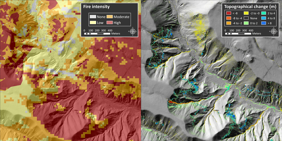
Fire intensity and erosion (shown as topographic change) after two storms in Bandelier National Monument following the Las Conchas Fire. Images courtesy of Richard Middleton, Los Alamos National Laboratory.
Atchley, A.L., Kinoshita, A.M., Lopez, S., Trader, L., Middleton, R. (2018). Simulating surface and subsurface water balance changes due to burn severity. Vadose Zone Journal, doi: 10.2136/vzj2018.05.0099. Available here. |
Satellite-based Evapotranspiration Estimates after Wildfire
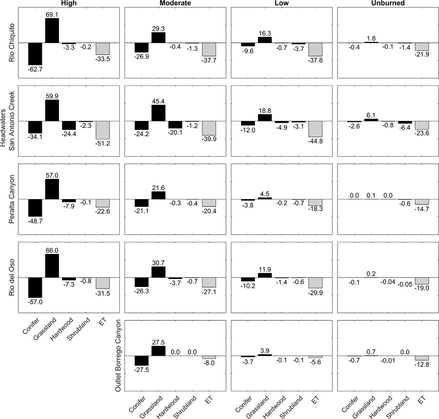
Percentage difference in pre- and post-fire ET (% ET) and the difference of total vegetation from 2010 to 2012 for high, moderate, low, and unburned SBS within RioChiquito, Headwaters San Antonio Creek, Peralta Canyon, Rio del Oso, and Outlet Borrego Canyon watersheds.
|
Patrick Poon's M.S. research focused on the evaluation of spatial and temporal changes in evapotranspiration (ET) following the 2011 Las Conchas Fire in New Mexico (USA) using the Operational Simplified Surface Energy Balance Model (SSEBop ET). Evapotranspiration is coupled with soil burn severity and analyzed for 16 watersheds for water years 2001–2014. An average annual decrease of 120 mm of ET is observed within the regions affected by the Las Conchas Fire, and conifers were converted to grassland a year after the fire. On average, the post-fire annual ET in high, moderate, and low burn severity is lower than pre-fire ET by approximately 103–352 mm, 97–304 mm, and 91–268 mm, respectively. The ratio of post-fire evapotranspiration to precipitation (ET/P) is statistically different from pre-fire conditions (a = 0.05) in nine of the watersheds. The largest decrease in ET is approximately 13–57 mm per month and is most prominent during the summer (April to September). The observed decrease in ET contributes to our understanding of changes in water yield following wildfires, which is of interest for accurately modeling and predicting hydrologic processes in semi-arid landscapes.
Poon, P.K, Kinoshita, A. M., (2018). Spatial and temporal evapotranspiration trends after wildfire in semi-arid landscapes. Journal of Hydrology. doi: https://doi.org/10.1016/j.jhydrol.2018.02.023. Available here. |
Additional work utilizes machine learning to conduct supervised learning on spatial actual ET with remotely sensed indices and variables. Traditional spatial ET methods are time and resource intensive; machine learning will provide an alternative solution and minimize user errors and computational challenges. Patrick's thesis work is the first to fully utilize remote sensing to examine the potential effects of ET due to large wildfires and to couple a machine learning method to develop SVM-ET6 to predict ET in a post-fire environment.
Poon, P.K, Kinoshita, A. M., (2018). Estimating Evapotranspiration in a Post-Fire Environment Using Remote Sensing and Machine Learning. Remote Sensing. doi: 10.3390/rs10111728. Available here.
Poon, P.K, Kinoshita, A. M., (2018). Estimating Evapotranspiration in a Post-Fire Environment Using Remote Sensing and Machine Learning. Remote Sensing. doi: 10.3390/rs10111728. Available here.

|

|
This research was supported by NASA Headquarters under the NASA Earth and Space Science Fellowship Program (16-EARTH16F-233) and the SDSU College of Engineering.
Poon, P.K. (2018), Satellite-based Evapotranspiration Estimates After Wildfire, San Diego State University. Thesis available here. |
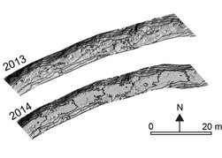 Channel digital elevation model (DEM) illustrates relatively rough bed before the 2014 storm and smoother bed after sediment deposition. Channel digital elevation model (DEM) illustrates relatively rough bed before the 2014 storm and smoother bed after sediment deposition.
Post-fire Sediment Dynamics SDSU M.S. student Samira Nourbakhshbeidokhti contributed LiDAR (light detection and ranging) terrestrial laser scanning (TLS) estimates and uncertainty analysis to a recent study by Florsheim et al. (2017). Florsheim et al. (2017) investigated post-wildfire geomorphic responses following the 2013 Springs Fire in southern California (USA), using multi-temporal terrestrial laser scanning and detailed field measurements. A small storm in WY 2014 generated sufficient flow to mobilize a portion of the sediment derived from the dry-ravel pulse and deposited the fine sediment in the channel. The LiDAR analysis showed this volume totaled ~0.60m^3/m (volume per unit length of channel). Storms during WY 2015 contributed additional fine sediment from tributaries and lower hillslopes and hyperconcentrated flow transported and deposited additional sediment in the channel. LiDAR and GIS analysis showed that together these sources delivered sediment on the order of six times that in 2014. Florsheim, J. L., Chin, A., Kinoshita, A. M., & Nourbakhshbeidokhti, S. (2017). Effect of storms during drought on post‐wildfire recovery of channel sediment dynamics and habitat in the southern California chaparral, USA. Earth Surface Processes and Landforms.. DOI: 10.1002/esp.4117. Available here. |
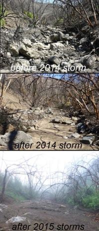
Study reach before and after the 2014 storm, and after the 2015 storms
|
Ecosystem Impacts from Recreational Trails in the San Bernardino National Forest
Many wildlands and forests in the United States are under substantial pressure from increasing human development and recreational demand. Recreational trails and users can significantly impact surrounding ecosystems and watersheds where developed systems are not thoroughly planned and maintained. Negative impacts to ecosystems and watersheds include noise pollution, erosion and geomorphic impacts, weed invasion, increased travel into virgin areas, water and soil pollution, decreased biodiversity near trails, and habitat fragmentation. Using a network of existing trails within the San Bernardino National Forest near Big Bear Lake, California, Ian Crano (SDSU M.S. Thesis) developed a simple Geographic Information System (GIS) based spatial analysis Trail Risk and Ecosystem Evaluation (TREE) method to assess the impacts of recreational trails and predict the impact of trails independent of field-based information. TREE minimizes the need for field-based surveys and data that can often be impractical, time intensive, expensive, and inconsistent due to variability in personnel experience, objective analysis, and training to improve the efficiency and accuracy of managing and implementing trail systems. A combination of locally and regionally available special status or sensitive species habitat locations, digital elevation models, soil types, and trail spatial data is utilized to determine the relative impact of each trail within a small subsystem of trails. Calibration and validation of the TREE-predicted impacts is performed utilizing field surveys. TREE can be widely applied to assess ecosystem impacts of existing and proposed trail systems not only in the San Bernardino National Forest, but also for a variety of land covers, geomorphic characteristics, regions, climates, and recreation types. This is critical for planning sustainable trail systems under climate change and managing increasing recreational demands.
Crano, I. (2016). Spatial Assessment of Ecosystem Impacts from Recreational Trails in the San Bernardino National Forest. San Diego State University. Available here.

|

|
Special thanks to the Big Bear Valley Trail Foundation for support and trail crews for their field assessment and data collection (Learn more here!)
We also thank the San Bernardino National Forest Mountaintop Ranger District. |
|
A Tale of Two El Niño Ready Cities: San Diego and Tijuana |

|

|
|
SD-TJ Intro-3-20-16-HD from akinoshita on Vimeo. CSU COAST Blog: Is San Diego an El Niño Ready City?
Report that summarizes a review of 15 countries affected by the 2015-16 El Niño. Available here. |
|
|
Alvarado Creek Restoration Alvarado Creek is an urban, channelized stream within the San Diego River watershed and has substantial non-native vegetation that contributes to frequent flooding. Students measure, collect, and analyze baseline and post-restoration hydrologic and geomorphic parameters, providing critical information for urban creek restoration efforts. Student activities are part of a restoration project funded by the San Diego River Conservancy. 2019-20 Field Team: Lauren Mathews, Quinn Walker, Kevin O'Marah, Sam Zorn, Margot Mueller, Dani Hunt, Rey Becerra, Maddy Hapgood, Sara McGaugh 2018-19 Field Team: Lauren Mathews, Kelly Flint, Kyler Stevenson, Jack Mikesell, Quinn Walker, Valerio Ruchay, Peris Salih, Kevin O'Marah, Sam Zorn, Sarah Mondloch 2017-18 Field Team: Sheikha al Rahbi, Fahmy Attar, Mike Violante, Kelly Flint, Patrick Poon, Kyler Stevenson, Jack Mikesell, Lauren Mathews, Nathan Harrison 2016-17 Field Team: Sheikha al Rahbi, Kelly Flint, Jesus Garcia, Clint Gibson, Patrick Poon, Rogelio Ruiz 2015-16 Field Team: David Edwards, Candi Granillo, Patrick Poon, Bernard Aparicio, Nick Avlani, Andrew Coulter, Ian Crano, |


|
|
|
|

 Differenced pre- and post-fire SCA
Post-fire Hydrology and Recovery
Current management practices are often concentrated around immediate post-fire effects (first storm season); however, burned systems are altered for prolonged periods of time. Estimating the changes in hydrology as a result of upstream landscape alterations and the uncertainty of post-fire recovery and behavior is critical for downstream communities. Applying remotely sensed data streams in post-fire environments facilitates monitoring of large and ungauged areas at high spatial and temporal resolutions; providing important information affecting recovery. Previous work in southern Californian watersheds shows geophysical characteristics and lack of vegetation recovery are related to significant changes in annual and seasonal discharge for seven years post-fire (Kinoshita & Hogue 2011). Further investigation shows that dry season flow is altered for a decade, with an excess water yield of ~2.3 ac-ft (Kinoshita & Hogue 2014). That's about 750,000 gallons of water! Current work strives to integrate spatial and temporal variability indicated by remote sensing data from satellite platforms to improve prediction of hydrological variables.
Kinoshita, A.M. & Hogue, T. S. (2015). Increased dry season water yield in burned watersheds in southern California.. Environmental Research Letters 10(1). DOI: 10.1088/1748-9326/10/1/014003. Available here.
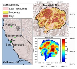
Post-fire Snow Covered Area
Micheletty et al. (2014) evaluate the spatial and temporal variability in snow after a large forest fire in northern California. MODIS MOD10A1 fractional snow-covered area and MODSCAG fractional snow cover products are utilized to detect spatial and temporal changes in snowpack after the 2007 Moonlight Fire and an unburned basin, Grizzly Ridge. Annual MODSCAG fSCA show statistically significant increased fSCA after the fire compared to pre-fire averages and Grizzly. The number of days exceeding a pre-fire high snow-cover threshold increased by 81 %, post-fire. Canopy reduction increases exposed viewable snow area and the amount of solar radiation that reaches the snowpack, leading to earlier basin average melt-out dates compared to the nearby unburned basin. There is also a significant increase in MODSCAG fSCA post-fire regardless of slope or burn severity. Regional snow cover change has significant implications for both short- and long-term water supply for impacted ecosystems, downstream communities, and resource managers.
(Micheletty received the 2013 Outstanding Student Paper Award in the AGU Hydrology Section)
Micheletty, P. D., Kinoshita, A. M., & Hogue, T. S. (2014). Application of MODIS snow cover products: wildfire impacts on snow and melt in the Sierra Nevada. Hydrology and Earth System Sciences, 18(11), 4601-4615.. Available here.
