Paid graduate research positions available for Summer 2021 and AY 2021-2022!
The Disturbance Hydrology Lab at SDSU focuses on understanding hydrologic change in coupled human-natural systems. Research seeks to improve predictions of hydrologic recovery in watersheds disturbed by anthropogenic activities and natural processes utilizing field studies, remote sensing, and modeling. Developed theories, methods, and models have significant regional and global implications, where rapid urbanization of wildlands is occurring. The available opportunities are described below. Follow us @sdsu_disturbance_hydrology
Post-fire vegetation and volumetric sediment regimes in urban systems
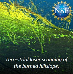
Human-ignited fires, drought, large fuel loads, and non-native vegetation have made urban streams and rivers into corridors for fire movement. The goal of this NSF-funded work is to understand and predict post-fire vegetation, soil, and stream interactions using a combination of field, remote sensing, statistical, and modeling methods. Riparian zones (areas adjacent to streams) are important regulators of secondary impacts such as altered pollutant fluxes and increased soil and erosion. Light detection and ranging (LiDAR) provide detailed images of the landscape, allowing documentation of the storage and supply of sediment as a function of non-native and native vegetation and hydrologic conditions. Satellite imagery will augment these relationships and document interactions at multiple spatial and temporal resolutions.
Dr. Kinoshita is seeking a graduate student to lead field work, analysis of LiDAR data, and modeling research to establish relations between vegetation patterns and sediment volume within the upland and riparian zones after fire; couple the recovery trajectory of in situ volumetric sedimentation and hydrologic response after fires; and develop a model to predict sediment flux following fires due to the evacuation of sediment stored behind vegetation.
Dr. Kinoshita is seeking a graduate student to lead field work, analysis of LiDAR data, and modeling research to establish relations between vegetation patterns and sediment volume within the upland and riparian zones after fire; couple the recovery trajectory of in situ volumetric sedimentation and hydrologic response after fires; and develop a model to predict sediment flux following fires due to the evacuation of sediment stored behind vegetation.
Forest fuel management and water yield
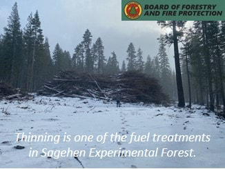
The forested Sierra Nevada acts as a natural reservoir collecting vast quantities of snow, supplying the majority of hydrologic needs for California and Reno Nevada. These landscapes are changing in response to intensifying climate, fire patterns, and biological invasion. The Sagehen Experimental Forest is undergoing extensive and variable experimental treatments to evaluate fuel management strategies. Funded by the Board of Forestry & Fire Protection and in collaboration with the Colorado School of Mines, this work will utilize and assess field data to evaluate the cumulative impacts of treatments at the watershed and subwatershed scale. The overarching goal of this research is to monitor, analyze, and develop statistical and physically-based models to quantify the response of streamflow to cumulative forest treatments in Sierra Nevada watersheds.
Dr. Kinoshita is seeking a graduate student to lead analysis of Light Detection and Ranging (LiDAR) data to estimate forest structure parameters. LiDAR data will also be used to detect vegetation structure change with respect to the treatments and compared to leaf area index (LAI), and other remote sensing products.
Dr. Kinoshita is seeking a graduate student to lead analysis of Light Detection and Ranging (LiDAR) data to estimate forest structure parameters. LiDAR data will also be used to detect vegetation structure change with respect to the treatments and compared to leaf area index (LAI), and other remote sensing products.
